Archive for Geopointe Category Feed

Geo-Analytics in Salesforce

A new version of Geopointe was just released and in it is the ability to perform Geo-Analytics on LOTS of data.  And it’s fully integrated with Salesforce and the current Geopointe app.

We have partnered with SpatialKey to bring you the Geopointe Analytics solution.  The SpatialKey platform allows you to perform deep geo-analysis against massive amounts of data in a very intuitive, enjoyable and beautiful user interface.

Geopointe Analytics is now available in all Geopointe trials.  Existing customers may request a trial of the Analytics solution in their current system (after upgrading to the latest Geopointe version).  If you are running an older version of Geopointe, you can learn about upgrading here.

End-users can access the features via the Visualize tab. There, they can sync their data sets to SpatialKey, use existing org-wide data sets provided by an admin or launch into the user interface using either a full map or “blank canvas” interface.

The Analytics users interface is very interactive and immersive. The following video gives you a taste of what’s offered, but the best option is to try it out for yourself.

If you have any questions about this solution, contact us.

Comments off comments feed

Proximity Searching via Apex

A new release of Geopointe will be out next week after all systems are on the Summer 11 release. With the update will come the ability to perform spatial/proximity/radial searches via Apex. Two new Apex methods are available for this:

  • radialSearchMapObject
  • radialSearchDataSet

These Apex methods enable Geopointe customers to utilize the proximity searching of Geopointe into advanced Apex logic. For information on all methods available to you, visit the Apex API page in the Help Center.

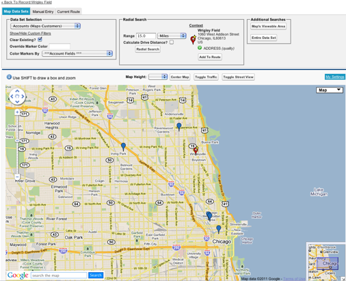
Let’s run an example.  The image below displays a query (via the Geopointe UI) of our Geopointe customers within 15 miles of Wrigley Field in Chicago. We want to accomplish this same query in Apex without ever needing the UI. Now we can and the geopointe.API class will help us with this.

Using radialSearchMapObject
This method allows you to perform a radial search against a Map Object (a Salesforce object enabled for mapping) and also allows the passing in of a custom filter. Here we are saying to search around the record with id a1430000001E32gAAC and to search the Account object with a filter of Type = ‘Customer’ for records within 15 miles.

geopointe.API.radialSearchResult result = geopointe.API.radialSearchMapObject(
     'a1430000001E32gAAC',
     'account',
     'type=\'Customer\'',
     15,
     geopointe.API.units.MILES);

system.debug(result);

Using radialSearchDataSet
The method below is accomplishing the same thing, but is using a pre-defined dataset that already has the filter for Customers built into it.

geopointe.API.radialSearchResult result = geopointe.API.radialSearchDataSet(
     'a1430000001E32gAAC',
     '12826856169860.9678661172894504',
     15,
     geopointe.API.units.MILES);

system.debug(result);

The radialSearchResult Class
Both methods result in a geopointe.API.radialSearchResult object, which is defined in the Geopointe Help Center. This object will return the record Ids closest to the center as well as the distances to these locations.

Comments off comments feed

Auto Run Radial Searches

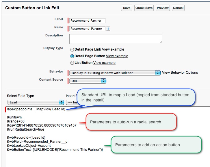
Oftentimes, you want to integrate a specific map search into your business processes. For example, suppose your Inside Sales team is reviewing Leads and needs to notify your closest partner of the lead information. Geopointe is the tool to help you know who your closest partner is and this entire process becomes even easier when being creative with the available URL Parameters for the Map page.

See this example in action in the video below.

The image below is a copy of the button configuration.

Comments off comments feed

Static Maps in Visualforce

Geopointe includes a Visualforce Component that allows you to create Static Maps on your Visualforce Pages.  A Static Map results in an image file (png, jpg or gif) that you can configure and place on your Visualforce Pages or embedded in Page Layouts.  The nice thing about Static Maps is that they do not slow down your pages from loading.  Rather, you are using the component to intelligently build an image URL.

Geopointe comes with some examples with the “embeddedMap…” pages.  These are pre-configured Visualforce Pages using the static map component to show you the location of a record.

We added a Static Map page on the website to act as the official documentation home for this functionality.  With Geopointe installed, you also get a documentation in your Component Reference regarding the geopointe:staticMap component.

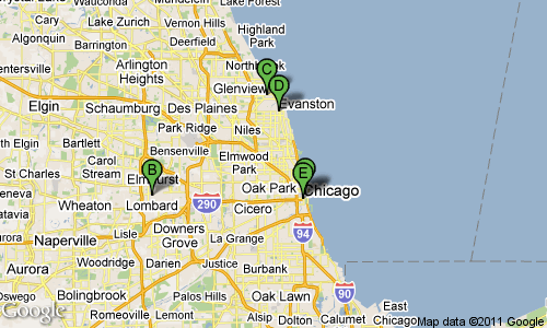
Below are some examples showing off the functionality.

<geopointe:StaticMap mapProvider=”goog” width=”500″ height=”300″ useIconLabels=”true” iconColor=”green” locationIDs=”a07A000000ATQjhIAH,a07A0000006O0qc,a07A0000006NKq2,Evanston|IL,OakPark|IL”/>

<geopointe:StaticMap mapProvider=”mq” width=”800″ height=”200″ useIconLabels=”true” iconColor=”purple” locationIDs=”a07A000000ATQjhIAH,a07A0000006O0qc,a07A0000006NKq2,Evanston|IL,OakPark|IL” mapType=”hyb”/>

Comments off comments feed

Geopointe 1.6

Geopointe 1.6 has been released on AppExchange.  The Update History page has the full list of changes in this release.  Below are highlights of the major changes, especially those that will impact end users’ experience with the application.  You should make your users aware of these changes.

Ad-Hoc Filtering

You can now apply filters to your queries from the Map page. You are no longer required to create and save a data set to get a filtered look at your data. You can still create and use Data Sets like before and this filter feature on the map page is a way to apply additional filters to the query. This feature should significantly reduce the number of data sets you require to have pre-created.

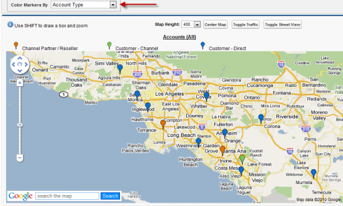
Coloring Markers

A new option called “Color Markers By” is available when mapping. This drop-down will list the fields you have available on the object. Selecting a field prior to clicking the map button tells Geopointe to ensure unique values from that field are put into a unique color. There are 20 pre-defined colors right now and they are the same colors used in Salesforce Dashboards.

Child Object Filters

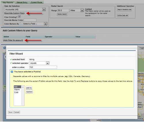
You have always been able to filter on parent records (e.g. show Opportunities linked to Accounts with an Account Type = Customer).  Now you can use Child Relationships to filter parent objects.  For example, the image below is for an Account data set and is filters for Accounts with:

  • Account Type starting with “Customer”
  • Opportunities that have been Won and are of an Amount > 10,000

Enhanced Data Tables

The table below the map was significantly enhanced to allow pagination, searching, improved sorting and better rendering of values based upon data type.

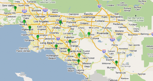
Numbered Map Markers

This feature can be enabled via a User Preference on the My Settings page. It will add a number of each pin on the map and the same icon will display in the table so you can easily see the relationship between the table and the map.

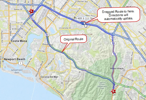
Draggable MapQuest Routes

MapQuest routes are now draggable.  Once you generate a route, drag the route line around the page to tell it you want to go a different way.

View State Issue Is Gone!

Previous versions could throw an error regarding “View State” if too many records were added to the map.  This issue has been eliminated.  As a result of this, performance on the page should also be greatly improved.

Additional Items

  • Added a user preference to hide the Salesforce Sidebar from the Map & Visualize page. By default, the sidebar is displayed.
  • Many performance and optimizations enhancements

Comments off comments feed

« Previous entries